Ahead of Hurricane Erin, the first Atlantic hurricane of the year, island communities off the coast of North Carolina are preparing for floods.
Authorities on a few islands near North Carolina’s Outer Banks issued evacuation orders and warned that some roadways might be swamped by waves of up to 15 feet (4.6 meters), despite forecasters’ confidence that the storm won’t directly hit in the United States.
The storm is still a powerful, deadly hurricane even though its top sustained winds have decreased to 130 mph (210 kph) by Monday night.
The U.S. National Hurricane Center in Miami issued tropical storm warnings for the Turks and Caicos Islands and the southeast Bahamas.
Here are some facts regarding Hurricane Erin.
Erin is expected to move northeast and away from the eastern United States, according to forecasters. Nevertheless, the storm is predicted to bring rip currents, hazardous seas, and tropical storm force winds to the coast of North Carolina. Dave Roberts of the National Hurricane Center says so. North Carolina’s coast is predicted to start flooding on Tuesday.
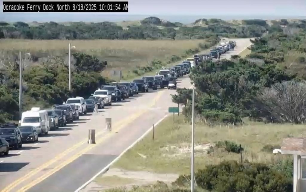
Despite the storm’s uncertain direct landfall, evacuations were being urged on Hatteras Island and Ocracoke Island near North Carolina’s Outer Banks. Authorities cautioned that 15-foot (4.6-meter) waves might drown several roadways.
On the narrow chain of low-lying barrier islands that protrude deep into the Atlantic Ocean, the orders are issued during the busiest travel season.
According to the National Weather Service, there are worries that parts of the main highway that runs along the barrier islands may be washed out by many days of strong winds, waves, and surf. For a few days, some routes might not be accessible.
Storm surge is most likely to affect parts of Highway 12 on Ocracoke and Hatteras Islands, according to Michael Brennan, director of the National Hurricane Center.
Thousands of people lost power on Sunday as Erin’s outer edges struck areas of Puerto Rico and the Virgin Islands with torrential rainfall and tropical storm-force winds.
The level at which sea water surges over its typical level is known as storm surge.
Storm surge excludes the wave height over the mean water level, much like continuous winds do not account for the possibility of even larger gusts.
A 15-foot storm surge at high tide can be significantly more destructive than the same surge at low tide since surge is also the amount above the average tide at that moment.
The Turks and Caicos Islands, home to just over 46,000 people, announced that all services had been suspended on three of its islands and that locals were being told to stay at home.
Strong winds and a lot of rain have affected the British territory’s easternmost islands the most.
According to interim Minister of National Security Jache Adams, Bermuda won’t experience the storm’s full intensity until Thursday evening. On Monday afternoon, services on the island remained operational.
However, Adams issued a dire warning that the waters will become unsafe for boating, swimming, and surfing by Thursday due to storm surge, which could reach up to 24 feet (7.3 meters).
Hurricane Ernesto created heavy surf and seas that caused coastal devastation a year ago, despite remaining hundreds of miles offshore from the U.S. Eastern Seaboard.
During the previous week, Erin’s strength has varied greatly.
The Saffir-Simpson scale is the most widely used method to gauge a hurricane’s intensity. A storm’s sustained wind speed in its center determines its category, with 5 being the strongest, on a scale of 1 to 5.
With gusts of 160 mph (260 kph) on Saturday, Erin reached a terrifying Category 5 category before waning. It is predicted to continue to be a powerful hurricane into the middle of the week.
You are facing a powerful hurricane. It varies in intensity. Richard Pasch of the Hurricane Center stated that the hurricane is deadly regardless.
This hurricane season has already seen four tropical storms, despite Erin being the year’s first Atlantic hurricane. An 83-year-old woman was murdered when her car was washed off a rural road in North Carolina due to flooding induced by Tropical Storm Chantal, which made the first landfall in the United States of the season in early July.
Additionally, floodwaters that overflowed Texas Hill Country on July 4th killed at least 132 people.
Two people were killed by flash floods that flooded areas of New Jersey and New York City a little more than a week later.


