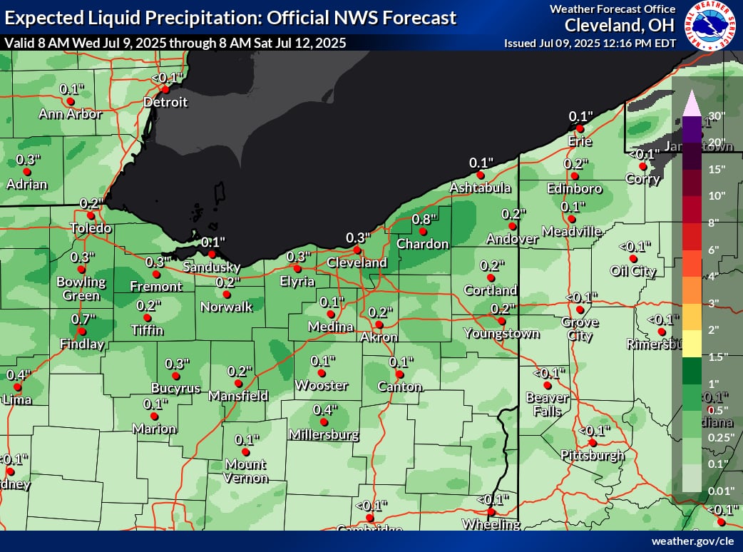
Cleveland, Ohio Unstable weather returns to Northeast Ohio on Wednesday after a little respite from the rain and humidity.
After midday on Wednesday, a disturbance in the upper atmosphere will move into the central Great Lakes region, increasing the likelihood of rain and thunderstorms.
Meanwhile, a warm front will be lifted toward Lake Erie by a weak low pressure system across Michigan, bringing in more precipitation and unstable air.
The environment will become more conducive to the formation of thunderstorms as a result, particularly as some stronger winds higher in the atmosphere will be assisting in this process. Thick clouds moving in, however, might restrict daytime heating, which would lower the total energy available for storm formation.
With increased coverage throughout Northwest Ohio this afternoon and early evening, there is a chance of showers and thunderstorms returning to the region today. Near-normal high temperatures in the low to mid-80s will prevail.Twitter: https://HOPkKhp17I to
In an amorning discussion, forecasters with the National Weather Service in Cleveland stated that it is difficult to anticipate just how widespread or intense storms will be because forecast models only indicate a moderate amount of instability Wednesday afternoon.
Later on Wednesday, forecasters still anticipate the formation of thunderstorms and at least a few isolated showers. Although there is still little certainty about where or how many pop up, any storms that do form could bring heavy rains and strong, gusty winds.
Additionally, there is enough moisture in the atmosphere to sustain localized flooding in areas where storms persist.
Rinse and repeat Thursday
Showers and storms will gradually stop on Wednesday night as a cold front passes over Northeast Ohio. The likelihood of storms will decrease as the sun sets and the environment cools.
A ridge of high pressure will attempt to move in from the north on Thursday. Nonetheless, it is anticipated that the same cold front will stall out close to Central Ohio, maintaining the possibility of sporadic showers and thunderstorms, particularly in the afternoon when midday temperature increases once more.
If a storm does develop, it may bring strong gusts and torrential rain. Even while Thursday’s storm coverage is predicted to be less extensive than Wednesday’s, the delayed front will still supply just enough fuel for some localized activity, especially in the central and southern regions of the region.
Both Wednesday and Thursday will see a considerable increase in humidity, with dew points getting closer to a muggier 70 degrees. Both days will see highs in the low to mid-80s.
Clearing out Friday with storm chances over the weekend
High pressure to our north will confine the stalled front to the south on Thursday night and Friday. In Northeast Ohio, this means fewer chances of storms or pop-up afternoon showers on Friday.
As a new weather system moves in from the Plains, that front will start to move back north on Friday night and into Saturday. The likelihood of showers and thunderstorms will gradually increase as warmer, more unstable air returns.
Forecasters say that Saturday night and Sunday, when a more powerful system passes through the Great Lakes and brings a cold front with it, offer the best possibility for more widespread storms.
The precise timing and intensity of this system are still somewhat unknown, but before the weekend is over, there may be a more structured round of rain and storms.
Friday and Saturday will see highs in the mid- to upper-80s and the low-90s, respectively. Heat indices might reach 100 degrees in some areas by Saturday, when the dew point is expected to rise into the 70s.
More
weather
-
Search continues for Texas flood victims as over 160 remain missing
-
Refreshing Tuesday in NE Ohio before storm chances, humidity return
-
When is the July full moon? How to see the buck moon


